Your cart is empty!
The Forest of Gravelway

Like everyone, we were meant to be somewhere else. Slovenia, in fact. But thanks to coronavirus, all grand plans of cycling in sunnier and more exotic climes had been quashed. So it was to Scotland we headed, with slightly more jackets than our original plan had demanded.
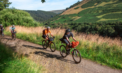
Our short trip began in Thornhill, on the eastern fringes of the Forest of Galloway. Ahead of us we had four days of gravel, road, wild camping and lochs. Having left the car and enjoyed a brownie or six, our route took us south, over rolling hills to Clatteringshaws Loch. It was raining. This was not an unanticipated occurrence, and the aforementioned jackets came into their own.

From there, we followed the famous “Raiders Road” through the forest. In normal times, this gravel track is open to cars - manic Polo drivers who have always yearned for a bit of adventure outside of the weekly Asda visit. Fortunately for us, it was closed (thanks corona) and it was in splendid isolation that we sped through the pine trees, past babbling becks (sorry burns) and in mercifully received sunshine.
A stiff climb up, and we sailed down the Laurieston Pass – three miles of sheer descent, backdropped by sun-kissed mountains, sea views and a setting sun. Day one finished in Gatehouse of Fleet with a (fucking amazing) steak and a short but futile stroll to the castle (closed).

What I am going to say next may surprise you. And I suggest you keep it to yourself, for if the secret should come out, I fear ruination. Ready? The gravel roads through the Forest of Galloway are... amazing. I’ve lived a long life. 29* years in the UK have taken me and my bike all over this fair and rainy isle. And I genuinely think this day’s riding was one of the best I have ever had. Why? It had everything. Great, rideable gravel. Breathtaking views. An absence of roads, shops, life, tourists. Just sheer emptiness. Go. Tomorrow.
*OK. 39. Whatever.

We wild camped by a reservoir just short of Loch Doon. It was raining.
Day three took us around the loch and over some (not so public) gravel roads stolen from the OS map back into the wilderness. We followed the Water of Ken up the valley and, with the obligatory bit of a hike-a-bike, some bog and general hilarity from passing Germans, made it over the other side. The roads heading east are tiny, single tracked affairs, sitting in a riot of green mountains, and crossed only by man-eating cattle. Also, mercifully downhill. We flew down to the illustrious town of Sanquhar to spend the night. The Forest of Galloway is full of subtle allure and wild beauties. Sanquhar is not one of them.

Our last day relieved our tired legs with some tarmac. We headed up the Mennock Pass, a nicely gentle Alpine-style climb with glorious views of big hills, big skies and big people in dressing gowns “wild” camping in their cars. At the top we had the glory and honour of reaching Scotland’s highest village, Wanlockhead, which stands at a lofty 400 metres above sea level. No oxygen needed. I had hoped for an opportunity to acquire some “Scotland’s Highest Village” souvenirs – a t-shirt, a mini haggis on a keyring, even a mini haggis without the keyring, but no such luck.
We sped bracingly down to Leadhills. It was raining. From there, we headed up the equally lovely Dalveen Pass. This lesser-known hill winds gently up from the windswept valley, cinching between tight hills and leaving the main roads behind. Once at the top, we descended for what felt like miles to brownie territory and the car in Thornhill.

Four days later – mud-covered, tired, and bitten to shit we returned, but with a real sense of adventure. The UK may be compact, busy and modest in scale. But in some small corners you can forget yourself, lose yourself, and genuinely get away from it all. This is the Forest of Galloway. But shush, don’t tell anyone I told you.


